
By adamg on Sun., 10/16/2016 - 4:03 pm 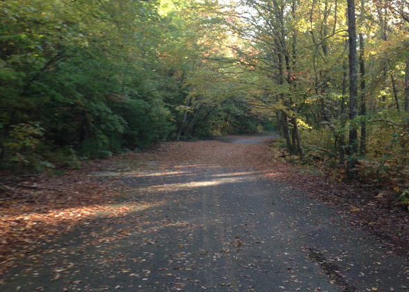
Tim Smith took a walk along the former 128 in the Blue Hills Reservation, left over from the days when 128 was cobbled together out of existing roads, before the current road was built a couple miles further out.
Neighborhoods:
Free tagging:
Like the job UHub is doing? Consider a contribution. Thanks!
Ad:
Comments
Old 128
By John
Sun, 10/16/2016 - 4:20pm
If I am not mistaken this is the old route 128, it was replaced with what we now use.
Are you sure that isn't the
By Damaged
Sun, 10/16/2016 - 8:42pm
Are you sure that isn't the segment of the old 128 that goes from Hougtons Pond and is bisected by I95?
Maybe Old 128?
By Dave G
Sun, 10/16/2016 - 8:49pm
This looks more like the Old 128 in the Blue Hills than it does the unbuilt Southwest Expressway.
Indeed this is the Olde Rte 128
By Tim Smith
Mon, 10/17/2016 - 9:42am
It is easy to find, shows up on the Blue Hills Map and is perfect for a zombie short film (cuz its only about 1.5 miles long...). Except for the buzzing of cars on 93, it is quite idyllic.
Folks, you are right
By adamg
Sun, 10/16/2016 - 10:10pm
Tim did identify the road correctly and I screwed it up. Fixed, thanks.
For what it's worth, there are still parts of the original 128, the one before the current one, that you can actually drive on. Walnut Street in Newtonville, for example.
Building Route 128 is a pretty cool that includes a fair amount of content on the original 128, cobbled together out of existing roads (such as Walnut) before the all new road was built a couple miles further west.
Old 128
By Island Guy
Mon, 10/17/2016 - 6:24am
Back in the day when I was determined to walk every trail in the Blue Hills Reservation, I came across this section of road.
It was like walking into the Twilight Zone. I wasn't a native Miltonian or even a long-term local, so there was no context for this Road from Nowhere going to Nowhere.
Ooo Wee Ooo.
Maps
By Ron Newman
Mon, 10/17/2016 - 11:23am
This map and this map show the "Old Route 128" trail, just above the interchange of I-93/128 and Route 24. The trail stands out because it is a solid line instead of a dashed one.
Yes!
By fairlee76
Mon, 10/17/2016 - 11:56am
One of my favorite local dog walk spots. It's a micro-version of the book "The World Without Us" come to life.
I'm partial to the abandoned
By chaosjake
Mon, 10/17/2016 - 12:49pm
I'm partial to the abandoned ramps that were intended to take the unbuilt Southwest Expressway/I-95 due north through Fowl Meadows and into Copley Square.
[img]https://scontent-lga3-1.cdninstagram.com/t51.2885-...
The SW Expy wouldn't have
By DTP
Mon, 10/17/2016 - 1:11pm
The SW Expy wouldn't have gone anywhere near Copley Square. It would have ended at an interchange with also-cancelled I-695 at what is now Ruggles.
South End Bypass
By Ron Newman
Mon, 10/17/2016 - 1:21pm
The cancelled highway plan included a "South End Bypass" which would have continued up the rail corridor from Ruggles towards the Mass Pike at Back Bay station.
Source please? I have never
By DTP
Tue, 10/18/2016 - 9:10am
Source please? I have never heard of such a plan. Everything I've ever read had the SW Expy ending at 695, with 95 following 695 over to 93 via the right of way that is now Melnea Cass Blvd. I've never read any mention of anything continuing from Ruggles to Back Bay.
You're right, the proposed
By chaosjake
Mon, 10/17/2016 - 5:12pm
You're right, the proposed route for the Southwest Expressway wandered around a lot in the decades before it was cancelled, but I don't think it ever wandered all the way to Copley. I just mentally put it there because of the SW corridor park.
One thing we can all agree on: Highway planning in Boston used to be insane.
[img]http://i.imgur.com/L9New8x.jpg[/img]
Google map of it.
By anon
Mon, 10/17/2016 - 9:12pm
Google map of it.
Add comment